
Before the quake, Haiti looked like this.

And now looks like this.
View Larger Map
During the response, it was clear that better coordination tools were needed. With regards to OpenStreetMap editing, a tool to show where edits were occurring and where further efforts should be focused was necessary.
Our own OSM Mapper, currently runs on a 48hour update cycle and was of little use for coordinating live, crowdsourced map edits. We hope to be running on a much shorter update cycle in the future, which should be of more use for coordination during future events. However, it does give us some useful insight after the event.
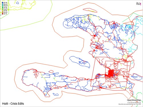
Looking at the OSM edits up to midnight 15th of January, red edits are the most recent. We can see a focus on Port-au-Prince and surrounding urban areas, which are presumably the worst affected. However, as relief efforts focused on the capital, access and awareness of the surrounding localities will be limited. These areas need to be mapped too and some mappers encouraged to make edits away from the main urban centres.
Looking through the tagging, 147 spontaneous camps of people displaced by the earthquake had been identified and tagged on the map. OSM Mapper has a handy KML export option, allowing you to focus on just one tag and export all the relevant features from OpenStreetMap in KML.
You can download the KML file of spontaneous camps here.
We are looking at running an update, and will get some images online to show progress after 15th January.


No comments:
Post a Comment